|
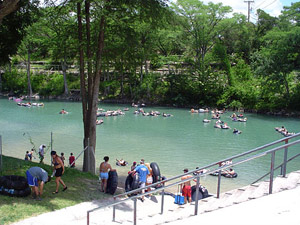 |
Toobers on the
Guadalupe River |
This 24-mile section of the Guadalupe River in Comal County is considered
one of the finest white-water stretches in the State. The river is scenic,
with limestone bluffs, baldcypress, pecan, elm and other vegetation lining
the banks. The river area presently is being subjected to intense development,
with many subdivisions and fishing camps becoming evident. However, many
natural areas can still be found. The flow of the river is largely controlled
by water releases from Canyon Dam. Good conditions for recreational use
are at all levels between 50 and 1000 cubic feet per second (CFS).
However, the most pleasurable conditions are available when the flow
is between 450 and 750 CFS. The water is very cold and clear since it
come directly form the bottom of Canyon Reservoir.
Several low water dams located on this stretch are hazardous to recreationists.
A major waterfall Slumber Falls is passable if extreme caution is exercised.
 |
|
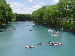
Toobers on the
Guadalupe River |
|
The remaining potential hazards are the low water road crossings and
the many rapids which span the river. Some of the better rapids which
can be hazards to recreationists are the Boulder Rapid, the Hueco Springs
Rapid, and the Rock Falls Rapid. Beyond the hazards and rapids mentioned,
the remainder of the river is serene and placid. The river flows gently
past limestone bluffs and baldcypress-lined banks.
Flowing southeast and joining the Guadalupe River at New Braunfels is
the Comal River which has its source in the hilly, large Comal Springs
within the city. The Comal is the shortest river in Texas, being only
two and one-half miles in length and having an average flow of 330 cubic
feet per second. This flow adds significantly to the flow of the Guadalupe.
Of particular interest to the recreationist are the many fishing and
swimming camps, Landa Park, and the textile industry in New Braunfels.
A small dam and several small spillways requiring portages are located
along the river. Flowing over smooth limestone beds with numerous small
rapid areas, the Comal is open for recreational usage year-round with
the spring and summer months being highly utilized. Additional waterway
features on the Guadalupe and distance between each are as follows:
 Corps
of Engineers park - immediately below Canyon Dam. A road to the left of
a hill takes cars down to the river just below the spillway. Corps
of Engineers park - immediately below Canyon Dam. A road to the left of
a hill takes cars down to the river just below the spillway.
Private camp - off FM 306, 2 miles southeast of Canyon City. (2 miles)
FM 306 crossing - 2 miles east of Canyon City. The high bridge provides
poor access. (1 mile)
Private camp - 3 miles east of Canyon City off FM 306. Facilities are
available for camping and picnicking and about 2 miles of shoreline provide
access. (0.5 mile)
FM 306 crossing - 3 miles east of Canyon City. The high bridge provides
poor access. (0.5 mile)
River Road crossing - county road crossing, off FM 2673. (2 miles)
Private road crossing - 2 miles south of Sattler. No access is available
unless permission is obtained to use the road. (1 mile)
Private camp - 4 miles south of Sattler on the river road. Approximately
1 mile of shoreline is available, and camping and picnicking facilities
are provided. (3 miles)
Private camp - 5 miles south of Sattler on the river road. Approximately
1 mile of shoreline is available along with camping and picnicking facilities.
(1 mile)
River Road crossing - 6 miles north of New Braunfels. (1 mile)
Private camp - 6 miles north of New Braunfels off the river road. About
1 mile of shoreline is available along with camping and picnicking facilities.
(0.1 mile)
Private camp - 5 miles north of New Braunfels. About one-half mile of
shoreline is available. Camping and picnicking facilities are provided.
(1 mile)
River Road crossing - 4 miles north of New Braunfels. (1 mile)
Private camp - 4 miles north of New Braunfels on the river road. About
1 mile of shoreline provides good access. Camping and picnicking facilities
are provided. (1 mile)
River Road crossing - 3 miles north of New Braunfels. (1 mile)
Private camp - 3 miles north of New Braunfels, just downstream from the
last river road crossing. (0.1 mile)
Private camp - 2 miles north of New Braunfels at Hueco Springs. (1 mile)
Gruene Crossing - county road between FM 306 and SH 46, 1 mile north of
New Braunfels. (3 miles)
SH 46 crossing - located on the northern city limits of New Braunfels.
(1 mile)
Cypress Bend Park - A city park in New Braunfels provides 1 mile of shoreline.
Camping facilities are available. (1.5 miles)
Comal River - "The shortest river in Texas," enters on the right.
This river may be explored for 2.5 miles upstream to Comal Springs. Several
private camps are located along the banks. (0.5 mile)
IH 35 crossing - A Texas Parks & Wildlife boat ramp is located beneath
Interstate Highway 35 in New Braunfels. (1 mile)
|